• Saba island from above

    Hiking

    Saba

Provided by: Cees Timmers / Saba Tourist Board

Our travel guides are free to read and explore online. If you want to get your own copy, the full travel guide for this destination is available to you offline* to bring along anywhere or print for your trip.​

*this will be downloaded as a PDF.

Price

€4,95

Purchase
The Ladder

The Ladder

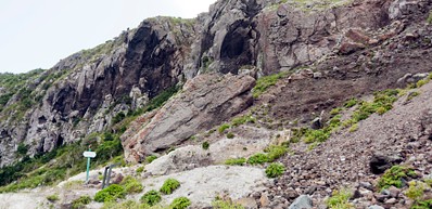
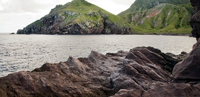
The stairway begins near The Bottom, a short distance past the hospital. From the lookout at The Gap, continue down a steep road through a residential area. The Ladder begins where the steps veer off to the left. The stairs were used until the 1970's to bring up cargo from the Ladder Bay to the Bottom. This historical trail overlooks the Saba Marine Park and the Diamond Rock. Occasionally, depending on the tide, there will be a black sand beach at the end of the trail in the bay area. The Highlights of this trail include views of coastal bluffs, old Custom's house and ocean vistas.
Read more
Crispeen Track

Crispeen Track

The Crispeen Track begins a short distance past the dormitory in The Bottom and is well marked. Follow the signs to either bud's Mountain Trail or The Bottom hill Trail. The trail to Rendez vous begins above the last house on the left. The trail enters a rain forest and passes through fields and over a forest ridge. The trail continues into pasture land and on to junction with the Mt. Scenery Trial. Access to Crispeen Track from Mt. Scenery/Windwardside is via Rendez vous trial.
Read more
Mas' Cahone's Hill, also known a Maskehorne Hill

Mas' Cahone's Hill, also known a Maskehorne Hill

Look for the trailhead signboard on your left as you head up Mt. Scenery from Windwardside. The route passes through landscape with lush vegetation thick with Elephant ears and climbs past tall boulders. If you are looking for a shorter and easier hike, as compared to Mt. Scenery, then this is your go to trail. Although you won’t get the panaromaic views that Mt. Scenery provides, Mas Cahones Hill offers it’s own breathtaking views of the village of Windwardside. Highlights: Views of Windwardside
Read more
Mt. Scenery

Mt. Scenery

The stairway to the top of Mt. Scenery begins just west of The Trail Shop in Windwardside. Appropriate footwear is necessary as the steps are often slippery. Mt. Scenery is the highest point in the Dutch Kingdom (877m or 2877ft) and is Saba’s dominant feature. Dense vegetation with a variety of species cover the summit and upper slopes. The Elfin Forest (cloud-forest) dominates the upper 50m (150ft) of the mountain and is comprised of Mountain Mahogany covered with Epiphytes, Orchids and a myriad of other unique and rare plants. Highlights: Secondary rain forest, fascinating changes in vegetation along the way, abundant bird and spectacular views of neighboring islands.
Read more
Sandy Cruz

Sandy Cruz

The trail extends from Upper Hells Gate to Troy Hill and is a favorite amongst tourists. For the most part, Sandy Cruz is a relaxing nature trail, although you will find some parts of the trail have quite an incline. Enjoy the tranquility that Sandy Cruz offers, walking along to the sounds of chirping birds and rustling leaves. Take the time to enjoy the flora and fauna and you might even be joined by a snake or two throughout your hike! Highlights: Primary rainforest, secondary rainforest, abundant bird life and spectacular views.
Read more
Sulphur Mine

Sulphur Mine

From the Windwardside, as you pass the church at Hell's Gate, make a sharp left at the second road to your left (which leads to the old Gate House Hotel). Continue driving along he road until your reach the ends of it, there is a private home on the left hand side. At the trail junction, follow the sign and continue down to your right. Once you reach a grassy area overlooking the sea, a short scrabble down the sulphur deposit will lead you to the mind entrance. Unfortunately, it is no longer possible to enter the mine, due to safety reasons. However, enjoy the spectacular views that this hike offers, and depending on the time of the day you can even see Saba's only airline making its decent to the shortest commercial airport in the world! Highlights: Views of Green Island, the Pirate Cliffs above the airport and the steeply eroded North Coast. Sea bird watching is exceptionally rewarding in this area.
Read more
The Tide Pools

The Tide Pools

A road just before the airport building goes down to Cove Bay and Flat Point. At the bottom of the road, walk out to the bluff overlooking the ocean. There is no trail as such. The tide pools are a unique spot on the island and are worth a visit. This area should only be visited when the sea is calm. When seas are rough, waves crash into the tide pools causing them to become dangerous. However, caution should always be taken when visiting the tide pools, due to the jagged rocks that surround the area. Highlights: Tide-pools and views of the remains of the sugarcane boiling house.
Read more
Spring Bay- Kelbey's Ridge

Spring Bay- Kelbey's Ridge

From English Quarter, walk down the road to the right of the Agricultural Station. At the end of this road, the trail starts on your left. Continue down the path to Old Booby Hill and further down to Spring Bay. As you near the coastline, the vegetation becomes increasingly dry and the air more hot and humid. For this trail, it's especially important to bring along enough water and use sunblock. Highlights: Spectacular views of the ocean, the airport and the island.
Read more